Tag Archives: Siuslaw National Forest

Run Oregon: Pioneer-Indian Trail, Mt. Hebo area, Siuslaw National Forest

28 Feb
The clouds were rolling in at the summit.

The clouds were rolling in at the summit, which sits at 3,153 feet — a climb of about 1,400 feet from the Hebo Lake Campground.

There were some wet, sloppy areas along the Pioneer-Indian Trail on my late February run, but this is definitely a trail worth visiting.

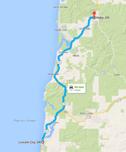
Hebo, Oregon, is just 30 minutes or so north of Lincoln City, and the trail takes off from the Hebo Lake Campground, just a few miles further up Forest Road 14.

The Pioneer-Indian Trail runs 8 miles from the campground to South Lake, which offers dispersed camping. I ran just 5 miles of the trail, making for a 10-mile out-and-back workout. I’ll have to run the entire length of the trail another day. The trail never strays too far from Forest Road 14, and many folks leave vehicles at both ends to avoid the out-and-back hike.

Mount Hebo vertical

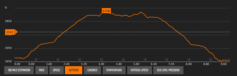
Mount Hebo elevation profile

From the Hebo Lake Campground, the trail climbs steadily for 4+ miles, winding through Douglas fir that were planted in 1912 after a massive fire. The trail is mostly single track, covered alternately in rocks, roots and forest trash. Hikers do share part of the trail with equestrians.

I saw just a couple patches of snow, but they say that the roads can become impassable due to snow in the winter. Traffic signs say the road is not maintained in the winter. Officially, the high point is 3,153 feet, although my GPS registered 3,159. The campground was situated at about 1,750 feet, which means the trail averaged a 6.5% grade.

Forest Service map, Mt. Hebo area trails

TRAIL MAP

Lincoln City to Hebo map

LC to HEBO

The top of the mountain features a long, open meadow; the temperature dropped noticeably, and there was nothing to stop the wind.

The trail itself gets its name because it was originally the route for Indians and then settlers to cross the Coastal Range from the Willamette Valley.

On a clear day, you can see the Cascade Mountain Range to the east, the Pacific Ocean to the west or Tillamook Bay to the north. But there were enough low-hanging clouds during my visit that the view was limited.

Getting there: To reach the trailhead at Hebo Lake Campground, head 24 miles north of Lincoln City to Hebo. Turn east on Highway 22 and go just .2 miles to the Hebo Ranger Station. Turn right before the Ranger Station, and take the winding Forest Road 14 a little more than 4 miles to the campground. On the day I visited, the campground was closed, so I parked along the road, and ran to the trailhead, which was only about a quarter mile.


Hike Oregon: Harts Cove

4 Dec

This slideshow requires JavaScript.

The hike to Harts Cove is an easy one — mostly downhill on a good trail that was marred in November by just a couple of muddy spots and washouts. The hike back out is when you’ll pay for the satisfaction of seeing a stunning ocean vista, watching the waves crash into a hidden cove and listening to the barks of unseen sea lions. 

The trail descends 800 feet in about 2.5 miles from the trailhead to a meadow that overlooks Harts Cove. It would have been another 150 feet down to the shore; while the main trail to the overlook was easy to follow, finding a path down to the shore was not so easy, and I decided to pass on that trip on this chilly but sunny early winter day.

You’ll cross Cliff Creek and Chitwood Creek along the trail. On this day, a small bridge over Chitwood Creek was washed out, but the creek is small at this point and was still easily crossed without the bridge.

All in all, the scenery was spectacular — including Chitwood Creek falls that spill into Harts Cove — and the trail is easily reached from Lincoln City. This is a hike well worth your time.

Getting there: Head north out of Lincoln City on Highway 101. From the intersection of 101 and Highway 18, go another 4 miles, which will be shortly after mile marker 102. Look for a gravel road to the left — Cascade Head Road 1861; there will be a yellow gate at the road. From Jan. 1 to July 15, the gate will be closed, keeping vehicles off the road. From the gate, go 3.5 miles to the end of the road, where you’ll find the trailhead.

Harts Cove vertical

Harts Cove elevation profile

Hike Oregon: Drift Creek Falls

28 Nov

A 240-foot long suspension bridge that hangs 100 feet over Drift Creek and overlooks the falls is the highlight of this relatively easy hike. The groomed path that leads from the trailhead to the falls is wide and accommodating, but you will descend more than 300 feet in the 1.5 miles or so it takes to reach the falls.

On the return trip, you can take the north loop, which is not as wide or as well groomed and will add about .7 miles to the hike.

The trail is in the Siuslaw National Forest. There is a fairly large parking lot at the trailhead, and there is a good vault toilet there.

To reach the trailhead, head south out of Lincoln City on Highway 101 to mile marker 119. Turn east at Drift Creek Road. In about 1.5 miles, you’ll come to a “T” intersection. Turn right. Proceed for about a quarter mile, take a slight left onto a narrow, one-lane blacktop road. Follow this for 10.3 miles to the trailhead parking lot. This is a good road, but winding and narrow and there is two-way traffic. The way is well marked with signs to Drift Creek Falls.

This slideshow requires JavaScript.


Corrine Malcolm

Ultimate Cookie Monster. Lover of Bacon.

adventure nomad

Adventure. Travel. Photography.

over60hiker

Traveling Adventures of Dan & Hannah

Des Hikes Thru

Daily Journals on Thru Hiking ... AZT Thru Hike Starting end of March 2024

What's Your Dream?

Makin' dreams a reality

Must Hike Must Eat

Nature Your Soul | Nature Your Body

Running with Scissors

Careening through life as a mom, runner, ecologist, and writer

PACWEST Photography

Image your Life

Omni Running

All about running and having fun

A trail running guy

A journey into running trails and ultra marathons

Hike Mt. Shasta

Exploring the Mount Shasta Region

Just Call Me Shortcut

very specific thoughts from an Enneagram 5w4

distance ahead

Ultramarathons.

In the Shadow of the Rockies

Running the trails of Calgary, and beyond

Teton Romeo

Tails from Teton Valley, Idaho

Local Mind Media

Inside Reality of Being a Police Officer

Racing Through My Life

My Race Reports

wonderjess

where I do it all

Beaverhead 100K and 55K Endurance Runs

Run the remote and rugged Continental Divide National Scenic Trail in the Beaverhead Mountains dividing Idaho's Lemhi River Valley and Montana's Big Hole Valley.

The Daily Post

The Art and Craft of Blogging

One and a Half Runners

Don't be dumb in the first half, don't be a wimp in the second

amy c writes

words from a writer, runner and mama of twins

andrealinares

A topnotch WordPress.com site

Tim Tollefson

Trail junkie for Hoka One One; 2014 U.S. 50k Trail Champion; Physical Therapist, Mammoth Performance Lab Director; Coffee addict; Powered SRA Elite and GU; My wife and I have an open relationship with running...

Tasharama_A_Go_Go

Musings of a musician turned ultra runner

iowagirlontherun.wordpress.com/

Running down a dream.

Ultra Runner Girl

Writing about running, war zones, and everything in between

Dan's Marathon

Running long distances across the country

Chasing 42

Life, the Universe, & Running