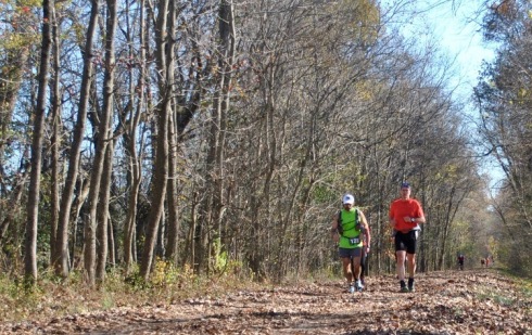
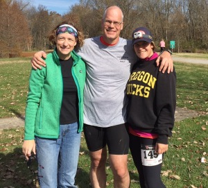
Dave Rogers, left, and I near Vienna, Ill., after completing 26 miles of the Tunnel Hill 100.
Karl Meltzer is a liar.
Harsh words, I know, but I was feeling harsh at mile 76.
Meltzer, a prolific ultrarunner, is known for famously uttering, “100 miles is not that far.”
On Saturday, Nov. 14, at 8 a.m., I set off on my first 100-mile ultrarun, the Tunnel Hill 100 trail run in Vienna, Ill. And for most of Saturday, I agreed with Meltzer. But in middle of the night, when Saturday turned to Sunday, I knew 100 miles was damn far.
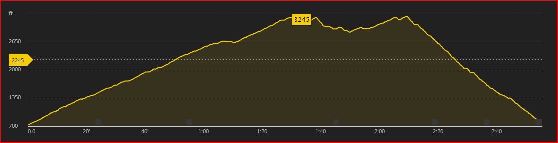
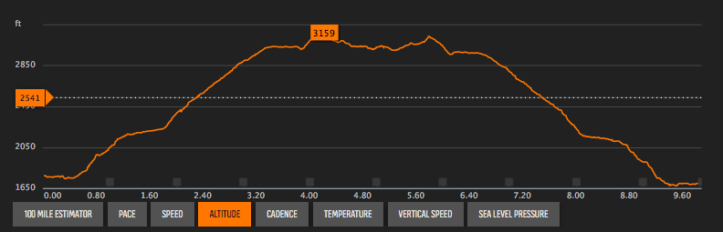
I had selected the Tunnel Hill race, I told my friends, because it was the easiest 100-miler I could find — as if any ultra of this distance could be “easy.” The race was about 5 hours south of our home in Keokuk, Iowa, in the tiny town of Vienna (pronounced “VY-enna”), about 25 miles north of Paducah, Ky. It takes place on a converted rail-to-trail, which means the grade is gentle or even flat.
I couldn’t have met my goal without the help of my wife, Barb, who ran 50 miles in the process, and my daughter, Laura, who hiked 24 miles and crewed for us.
As we ran out of the town’s city park in the chilly air, I made a concerted effort to dampen my pace. I am definitely not a fast runner, but I was trying to run even slower than normal. I knew I couldn’t afford to expend too much energy in the first hours of the race. I had outlined a plan for the race that called for me to complete it in 27 1/2 hours, but truth be told, I had no idea what it would take to finish or how long it would actually take.
The race has a 30-hour cutoff, which equates to an average of 18 minutes a mile. I took my best guess at my endurance and pace, and figured I’d start at a 13-minute pace and tail off to a 20-minute pace by the end. I knew the race would take its toll, and I wanted to be realistic.
The start/finish line was located in the middle of the course. You leave Vienna and head south for about 13 miles, hit the turnaround at the Barkhausen Wetlands Center and head back to Vienna. From there, you head north about 12 miles, reach a small turnaround and return to Vienna from the north. That gets you 50 miles, so you repeat the whole thing to record 100 miles.
I really did feel good through those first 26 miles. Instead of my planned 13-minute pace, I was running closer to 12 minutes, which is still slower than my normal pace and part of the reason I think it felt so relaxed.
I had planned on running the first portion by myself, but I picked up a fellow runner, David Rogers, about 5-8 miles into the run, and talking with Dave made the time pass so much easier. Dave and I had a lot in common: tackling our first 100s, roughly the same age, empty nesters, Midwest guys (he’s from St. Louis), etc. He could have gone at a faster pace, but he was trying to be controlled, too.

I refilled my bottles and picked up Barb at the start-finish line at mile 26.
When I ran into the start/finish area at mile 26, I hooked up with my wife, Barb, and daughter, Laura. Barb had agreed to pace me for 50 miles, which would help her reach that distance milestone and aid in my effort. She was going to run the middle 50 miles. Our daughter, Laura, was crewing for us, and at some point, she planned to run with me, too.
The next 24 miles would prove more difficult. In the first miles, I really couldn’t detect any change in the grade of the course. But just a few miles north of Vienna, it became obvious that there was a small but constant climb. The race info said it’s a 2 percent grade. That doesn’t sound like much, but 8 or 9 miles of even a small climb becomes tiring. About halfway into the climb, my left groin started to ache. I feared that it was going to cramp, but thankfully it never progressed beyond a nagging twinge.
We saw Laura at mile 36, refilled some bottles, made the turnaround in another couple miles and headed back toward Vienna.
By the time we reached there at about 7:30 p.m., it had been dark for three hours. Sunset was at 4:45 p.m., and we wouldn’t see the sun again until 6:30 a.m. — nearly 14 hours of darkness. If a relatively flat, straight, tree-lined, crushed limestone path presents a certain degree of monotony, you should trudge along that same path in the dark.
A few miles past what was the 50-mile mark for me and 24 for Barb, she began to struggle. Her stomach was queasy and her legs sluggish. After a mile or two, she insisted I go on ahead. I hesitated to leave her behind, but she continued to insist, and I relented. I soon met up with Dave again, and we’d stick together until the 76-mile mark at Vienna, when once again we’d get separated as we both refilled our hydration and nutrition and tended to our niggling injuries.

Barb can still manage a smile after completing her first 50-miler!
Laura had talked about going either 24 miles with me (the last out and back of the course) or waiting until the last 10 miles. We decided that if I could get to mile 90, there’s no way I wouldn’t finish, and so she took off with me out of Vienna — mile 76 or so at about 3 a.m.
Those last 24 miles turned from a slow jog to a moderate hike. I thought I was OK as I hit mile 76 at Vienna, but as I left that last major aid station, I just couldn’t will my legs to run. Thankfully, Laura helped me pass the time.
One of my big concerns was how I would even stay awake for the 24+ hours I knew it would take to complete the race. At one point, I asked Laura to talk to me — I needed something to keep my mind active and alert. She later said she wasn’t sure what she’d talk about, but that didn’t last long. I knew I could count on Lu for non-stop conversation! We’ve been doing that since we drove across Montana, South Dakota and Nebraska to attend Husker football games when she was 6 years old.
My muscles got stiff and tight, and my feet developed deep blisters. But in the end, finishing the race was simply a matter of continuous forward motion. I didn’t sprint across the finish line, but neither did I crawl. And I beat my goal time.
While I’d had doubts about finishing the race before I had started, once I’d hit the course and stuck with my pace, nutrition and hydration plans, everything really fell into place. Beforehand, I’d figured it would take me 27 1/2 hours to finish. Ultimately, I crossed in 26 hours, 48 minutes.
So in the end, maybe Karl Meltzer was right. My first 100-mile ultra really wasn’t that far.
Damn you, Karl Meltzer.
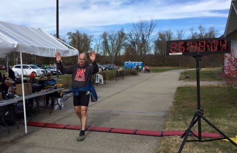
Crossing the finish line in 26:48:04. It was a great feeling to be done and reach a major goal.
Tags: keokuk iowa, trail run, Tunnel Hill 100, Ultramarathon, Ultrarun, Vienna Illinois