Tag Archives: ultrarunning

Run Oregon: Pioneer-Indian Trail, Mt. Hebo area, Siuslaw National Forest

28 Feb
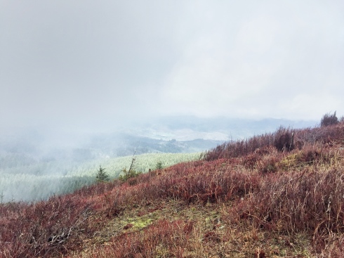
The clouds were rolling in at the summit.

The clouds were rolling in at the summit, which sits at 3,153 feet — a climb of about 1,400 feet from the Hebo Lake Campground.

There were some wet, sloppy areas along the Pioneer-Indian Trail on my late February run, but this is definitely a trail worth visiting.

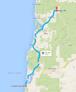
Hebo, Oregon, is just 30 minutes or so north of Lincoln City, and the trail takes off from the Hebo Lake Campground, just a few miles further up Forest Road 14.

The Pioneer-Indian Trail runs 8 miles from the campground to South Lake, which offers dispersed camping. I ran just 5 miles of the trail, making for a 10-mile out-and-back workout. I’ll have to run the entire length of the trail another day. The trail never strays too far from Forest Road 14, and many folks leave vehicles at both ends to avoid the out-and-back hike.

Mount Hebo vertical

Mount Hebo elevation profile

From the Hebo Lake Campground, the trail climbs steadily for 4+ miles, winding through Douglas fir that were planted in 1912 after a massive fire. The trail is mostly single track, covered alternately in rocks, roots and forest trash. Hikers do share part of the trail with equestrians.

I saw just a couple patches of snow, but they say that the roads can become impassable due to snow in the winter. Traffic signs say the road is not maintained in the winter. Officially, the high point is 3,153 feet, although my GPS registered 3,159. The campground was situated at about 1,750 feet, which means the trail averaged a 6.5% grade.

Forest Service map, Mt. Hebo area trails

TRAIL MAP

Lincoln City to Hebo map

LC to HEBO

The top of the mountain features a long, open meadow; the temperature dropped noticeably, and there was nothing to stop the wind.

The trail itself gets its name because it was originally the route for Indians and then settlers to cross the Coastal Range from the Willamette Valley.

On a clear day, you can see the Cascade Mountain Range to the east, the Pacific Ocean to the west or Tillamook Bay to the north. But there were enough low-hanging clouds during my visit that the view was limited.

Getting there: To reach the trailhead at Hebo Lake Campground, head 24 miles north of Lincoln City to Hebo. Turn east on Highway 22 and go just .2 miles to the Hebo Ranger Station. Turn right before the Ranger Station, and take the winding Forest Road 14 a little more than 4 miles to the campground. On the day I visited, the campground was closed, so I parked along the road, and ran to the trailhead, which was only about a quarter mile.


Scouting trip: Potawatomi Trail run

26 Jan

Click on any photo to launch the gallery.

Narrow trails, steep hills and slippery footing; sounds like fun!

I’ve spent a lot of miles on the road over the past 10 years, training for and competing in 17 marathons or half marathons.  But trail runs and ultramarathons are a whole new challenge. So if I’m going to tackle the Potawatomi Trail 50 in April, I figured I needed to reconnoiter the course.

And, boy, was it enlightening.

Here are a few of the things I learned on a short trail run on Saturday:

  1. 1,600 feet of rise is quite a bit. The race’s website said that runners will experience 1,600 feet of elevation gain during one 10-mile lap. I really had no context for that number. But after a 5-mile test run, I learned that means there are plenty of hills. There are quite a few very steep climbs on the trail, as you can see from some of the photos in the gallery above. Barb suggested I should add some workouts on the stepper into my routine, and I think that’s a pretty good idea.
  2. Trail speed and road speed are different. A review of lap times from previous years had me stumped. For the 50-mile race (they have a 100-mile and a 150-mile race, too), the fastest runner finished the first lap at about the same pace that I run a 10-mile training run. I know that I won’t be among the fastest runners, but I wasn’t quite sure how to judge those times. But after seeing the switchbacks, the steep ascents and descents, the slippery footing in what is probably some of the best trail conditions, I could understand why the times were so much slower.
  3. A single track trail will offer challenges in footing. This wasn’t a surprise, really, but today’s run put it in some perspective. There had been no recent rains or snows, and, with temperatures in the mid-20s, the trail was dry and firm. But that could easily change in early April. Plus the forest floor was covered in leaves, which were slippery as you made your way up or down steep slopes. And rocks and dried mud made for an uneven landing spot for your feet. I had debated whether I should purchase trail shoes, but after today’s run, I’m pretty sure I will.
  4. A number of steep hills means there will be a number of creeks. They were frozen or dry now. That may not be the case in April.
  5. Blisters could develop fast. Neither Barb nor I had any blisters after our 5-mile test run, but we had plenty of hot spots. Blisters probably weren’t far behind. The steep hills had our feet and toes working in ways that they don’t normally work on the roads. And in general, blisters can be a problem over an ultra. Some runners tape their feet before they even set out.

That’s a lot of learning for a simple 5-mile run.

Apparently, it was revealing for the wife and daughter, too. On the ride home, Barb asked if I really wanted my first 50-mile run to be on such a steep, winding trail. A 50-mile road run would be easier, she reasoned.

And daughter Laura, after seeing the photos of the trails, said, basically, I wasn’t very smart to tackle a challenge like this at my advanced age. (Well, some of that may be my interpretation of what she said.)

Admittedly, there is some trepidation on my part. By definition, a challenge isn’t easy. But it can certainly be fun.

♦ ♦ ♦

MISSION ACCOMPLISHED: Read this post for my race report on the Potawatomi Trail 50 mile run.

Corrine Malcolm

Ultimate Cookie Monster. Lover of Bacon.

adventure nomad

Adventure. Travel. Photography.

over60hiker

Traveling Adventures of Dan & Hannah

Des Hikes Thru

Daily Journals on Thru Hiking ... AZT Thru Hike Starting end of March 2024

What's Your Dream?

Makin' dreams a reality

Must Hike Must Eat

Nature Your Soul | Nature Your Body

Running with Scissors

Careening through life as a mom, runner, ecologist, and writer

PACWEST Photography

Image your Life

Omni Running

All about running and having fun

A trail running guy

A journey into running trails and ultra marathons

Hike Mt. Shasta

Exploring the Mount Shasta Region

Just Call Me Shortcut

very specific thoughts from an Enneagram 5w4

distance ahead

Ultramarathons.

In the Shadow of the Rockies

Running the trails of Calgary, and beyond

Teton Romeo

Tails from Teton Valley, Idaho

Local Mind Media

Inside Reality of Being a Police Officer

Racing Through My Life

My Race Reports

wonderjess

where I do it all

Beaverhead 100K and 55K Endurance Runs

Run the remote and rugged Continental Divide National Scenic Trail in the Beaverhead Mountains dividing Idaho's Lemhi River Valley and Montana's Big Hole Valley.

The Daily Post

The Art and Craft of Blogging

One and a Half Runners

Don't be dumb in the first half, don't be a wimp in the second

amy c writes

words from a writer, runner and mama of twins

andrealinares

A topnotch WordPress.com site

Tim Tollefson

Trail junkie for Hoka One One; 2014 U.S. 50k Trail Champion; Physical Therapist, Mammoth Performance Lab Director; Coffee addict; Powered SRA Elite and GU; My wife and I have an open relationship with running...

Tasharama_A_Go_Go

Musings of a musician turned ultra runner

iowagirlontherun.wordpress.com/

Running down a dream.

Ultra Runner Girl

Writing about running, war zones, and everything in between

Dan's Marathon

Running long distances across the country

Chasing 42

Life, the Universe, & Running